Common Land and Community Assets in Rural England
Common land in rural England carries rights, uses, and duties that vary by place. Learn how to check its history before planning a new use.
The most common mistake in discussing common land is treating it as land without an owner or rules. In rural England, common land may be privately owned while others hold specific rights over it, and that shortcut can hide who relies on the place and what permissions apply. A site’s history matters, but it cannot replace checking its present legal status.
Say a fictional village in England wants to add a walking route across a grassy area beside a stream. Residents remember grazing there, but they are unsure who owns the land or whether the existing path is a public right of way. Before choosing a route, the village needs to separate remembered use from recorded rights and current permission.
Common land in England involves specific rights
In England, “common land” is a legal category, not a synonym for land open to everyone. A common may be privately owned, while people known as commoners hold particular rights over it. Depending on the place and its records, those rights can include grazing animals or taking certain natural resources. The rights attached to a particular common are not interchangeable with general public access.
Public access is a separate question. Some common land has statutory access rights, but these do not authorize every activity, and exceptions or restrictions can apply. A public right of way is also distinct: it provides a right to pass along a defined route, not unrestricted use of surrounding land. The applicable rules depend on the site and the activity being considered.
These distinctions are useful because a field can look open while its legal arrangements are precise. An old gate, a worn track, or local recollection may offer clues, but none alone establishes ownership, a common right, or a public right of way.
Enclosure histories differ from place to place
In England, enclosure refers to processes that bounded or consolidated land and changed how land and rights were organized. The timing, methods, and consequences varied across places. Some common rights were restricted, transferred, or extinguished; other shared rights and open spaces continued. A general account cannot establish what happened on a particular common.
Changes in access could affect daily work as well as movement across the countryside. A household relying on grazing or gathering resources might face different terms after rights changed. A farmer could find that consolidated fields suited a particular way of managing land. These possibilities describe broad kinds of change, not the history of every parish or a substitute for local records.
For the fictional village, residents remember livestock on the grassy area, while an old hedge and gate suggest that access may once have been controlled. The recollections help identify questions for investigation. They do not establish that grazing rights remain, or that the streamside track is a public route.
New community uses can affect existing relationships
Rural spaces may be valued for recreation, habitat, heritage, or everyday connection, alongside their role in farming. Describing a place as a “community asset” can express a shared responsibility, but it does not by itself change ownership, create access rights, or settle existing obligations.
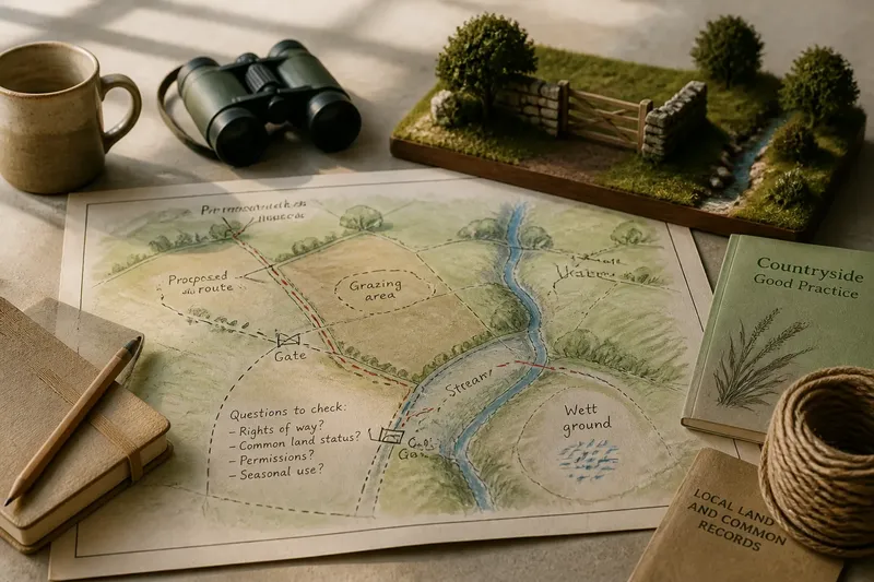
Imagine the fictional village proposes a marked path beside the stream. Residents want a clearer walking connection, while a farmer who uses the grass for seasonal grazing is concerned about dogs disturbing livestock. The group maps the proposed route, asks the landowner and relevant authority about permissions, and checks the site’s recorded status. If the route is permissible, it can be adjusted to avoid the grazing area and accompanied by clear information about responsible dog control. The result is a proposal with visible trade-offs, rather than an assumption that everyone can use every part of the land.
Stewardship connects access with ongoing care
Stewardship means taking responsibility for a place and considering how its uses affect it over time. On a rural common, practical concerns might include keeping a permitted path clear, maintaining a gate, or avoiding damage to a wet area. The appropriate work depends on the land and on who has authority to arrange it.
Access and stewardship are different responsibilities. A right to pass through a place does not automatically make someone responsible for maintaining it. Likewise, caring for a place does not necessarily give a group authority to change how it is used. Clarifying roles can prevent good intentions from turning into unauthorized work or conflicting expectations.
A site map can help residents describe current conditions. Mark visible paths, gates, streams, grazing areas, and places where the ground is soft. Add notes about seasonal use and questions that need confirmation. Treat the map as a planning aid, not proof of ownership or rights.
What should residents check before proposing a new use?
Does common land mean anyone can use it?
No. Common land in England can be privately owned and subject to specific common rights. Public access, permitted activities, and restrictions need to be checked for the particular site.
How can residents check whether a route is a public right of way?
Consult the local authority’s definitive map and statement, which record public rights of way, and ask the authority about any uncertainty. A track’s appearance or long use does not, by itself, confirm its legal status.
Where can residents look for information about ownership and common rights?
Check available land and common-land records, local authority information, deeds where accessible, and information from the landowner or relevant public body. Records may require interpretation, so consult a qualified land professional or legal adviser if a decision depends on the answer.
Can a village organize work on a common without permission?
Not necessarily. Ownership, common rights, conservation rules, and other site-specific requirements may affect what work is allowed. Ask the landowner and relevant authority before altering gates, paths, vegetation, or other features.
A local plan can record both known facts and open questions
For the fictional village, the next actions are to check the definitive map, ask the local authority about the common’s status, and contact the landowner about the proposed route. If those checks support a route, the group can draw an option that avoids the grazing area and note any seasonal concerns. If access or permission remains uncertain, it can pause the proposal or consider a route on land where permission is clear.
- Observation: the definitive map shows a public right of way crossing the proposed area. If the recorded route suits the plan, then design around it; if it does not, then ask the local authority about the mapped route before proposing a different one.
- Observation: the definitive map does not show the track residents remember. If the route’s status matters to the proposal, then seek clarification from the local authority; if it cannot be confirmed, then do not present it as a public right of way.
- Observation: records identify a landowner. If the proposed work affects the land, then ask that owner for permission; if ownership is unclear, then resolve that question before scheduling work.
- Observation: available records list common rights that may overlap the proposed route. If the plan could affect those rights, then seek advice from the relevant authority or a qualified land professional; if it avoids them, then record the basis for that conclusion and any remaining uncertainty.
- Observation: livestock use the area during a particular season. If the route can be placed away from the animals, then revise the map accordingly; if not, then discuss a different alignment or access arrangement with the landowner and affected users.
- Observation: the stream edge is soft or shows signs of trampling. If the proposed route would worsen the condition, then move it or seek appropriate site advice; if it would not, then state how the group will keep the route’s effects under review.
A short record can distinguish confirmed information from recollection and unanswered questions. For example, note that residents remember grazing, state whether a right appears in the records checked, and identify who will confirm anything unresolved. That record does not turn oral memory into legal proof, but it gives future discussions a clearer starting point.
When considering common land in England, ask not only what a place could accommodate, but whose rights and relationships a change might affect and who has authority to approve it. That distinction helps a village plan for a useful new purpose without mistaking an open-looking field for land without rules.